Posted on Mar 07, 2016 at 10:40 AM by andy.geall79
This route takes in some of the best road cycling in Calderdale and also pops over the hill to explore what Lancashire has to offer. The route starts in Todmorden and heads to Hebden Bridge on the valley road before picking up the route of the 2015 Tour De Yorkshire heading up ‘Calderdale Road Climb 13’ Keighley Road (Hebden Bridge to Cock Hill).
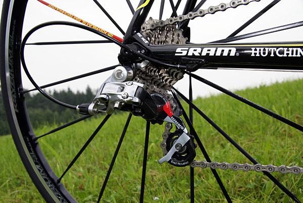
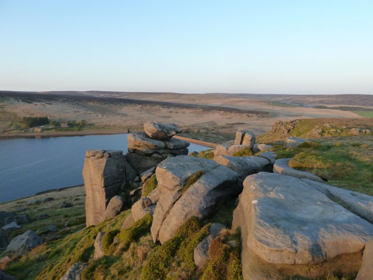
This climb is very popular with road cyclists from both sides as it was also part of the 2014 Tour De France. This route follows the pedal strokes of the pros to the outskirts of Oxenhope before heading up a beast of a climb; this climb varies in gradient up to Warley Moor Reservoir. The views on a clear day are brilliant unlike the road surface which is rough and patchy for a short section, cyclists riding their best bikes may wish to take it easy through this section of the route.
From one of the high points on this ride the route descents to the village of Wainstalls before plunging into the Luddenden Valley, the descent is very steep and requires good bike handling skills on the cobbles above Jowler Mill, this descent ends in the valley floor before reaching the tiny hamlet of Booth.
From Booth you pass the cricket club and local farms before heading down the valley further to Luddenden Foot which is one of the lowest points in the Calder Valley. Your visit to this part of the world is brief as you immediately head up the opposite hillside on ‘Calderdale Road Climb 34’ that links to the area of Sowerby.
From Sowerby you sneak through the back roads and head towards Triangle and the valley road to Ripponden. At Ripponden you climb again up the A58, this climb is long but not that hard compared to what you have already accomplished. This climb is very much like a mini version of a mountain pass as you reach the summit and head down the other side to Littleborough.
At the traffic lights in Littleborough you turn right and follow the road almost back to the start. Riders that are feeling tired can simply keep rolling and head back to Todmorden. Those that have the determination to continue will next take on ‘Calderdale Road Climb 28’ Shade to Sharneyford. This might be one of those climbs you either love or hate, it starts off fairly easy and it heads up through Gauxholme. Leaving the houses behind you the tree lined road kicks up to Cloughfoot offering a brief rest bite. From here the climb can be open to the elements and the road kicks up to the summit.
From Sharneyford the route descends into Bacup and is very much up and down from this point in. You leave Bacup and head towards Burnley on a long steady climb towards ‘The Deerplay’ that was once a local pub. The next descent is great, you have a full view of the road ahead and the gradient is steep enough to carry good speed without being on your brakes constantly. Around 2km into the descent knock off some speed as you are looking for a left, then instant right turn onto Crown Point Road. This road is very scenic and traffic free following an up and down profile. The roads high point offers views over Burnley with Pendle Hill in the background. On a clear day you can see the 3 Peaks in the distance.
At the end of Crown Point Road turn right and then right again at the traffic lights. As you head down the hill you will approach a strange looking junction, from here follow the signs to Todmorden, 12km along the A646 you will be back in the town for some well-deserved food and drink, reward yourself.
Posted on Mar 03, 2016 at 13:18 PM by andy.geall79
This 44km road ride starts in the small village of Walsden outside the local train station. The village has a small number of shops and facilities and a cracking fish and chip shop that opens during the week. At Cycle Calderdale we would advise you complete the route before tucking into some of Grandma Pollards finest delights.
Back to cycling the route heads south along the A6033 towards Summit which is famous for the Summit Tunnel Railway fire in 1984. From this point the road is fast flowing down to the town of Littleborough. At the traffic lights you turn left and head onto the first climb of the ride ‘Calderdale Road Climb 03’ Blackstone Edge. This climb is the toughest of three climbs that share the same summit point, one of which is the famous ‘Calderdale Road Climb 01’ Cragg Vale.
The Blackstone Edge climb is a real mixed bag with steady gradients on the lower slopes before the road ramps up hugging the hillside. The weather can be a real feature on this climb and help or hinder your progress. The road is open on the steeper slopes and the views down the valley you started from are superb on clear days.
As you reach the top you continue on the A58 down a fast descent towards Baitings Reservoir, from here the route takes on a rural road twist and follows some of Calderdale’s quiet country lanes. This road network is quite complex and some of the roads merge into farm tracks and bridleways. Carrying a map of the route or downloading the map file is advisable for this section of the ride.
After snaking around the country roads of Calderdale the route links back into the climb of ‘Cragg Vale’ and heads north and downhill to the village of Mytholmroyd which is a great place to refuel with a range of facilities on offer.
Leaving Mytholmroyd the route is straight forward as you follow the A646 to Todmorden, turn left at the roundabout and continue back to the start.
Read More
Posted on Mar 02, 2016 at 14:15 PM by andy.geall79
The White & Red Roses Mini Road Ride brings you another offering of hilly cycling around the Upper Calder Valley town of Todmorden.
The route starts in the centre of the town and heads east towards Hebden Bridge, on the outskirts of the town you embark on the first climb of the route ‘Calderdale Road Climb 40’ Cross Stone Road. The climb breakdowns into 3 sections and begins with a super steep slope that twists up the hillside. This follows with a short rest period as the route hugs the hillside and the climb ends with another sharp shock up to the landmark of Great Rock.
From here the route continues to climb until you reach Long Causeway and one of the high points on this ride. On a clear day you can look behind and admire the views down the Calder Valley.
The next part of this ride is truly fantastic as long as the wind isn’t in your face. From this point you gradually descend to Mereclough and the road kicks up on occasions but nothing challenging. On most days this entire section of road is fast rolling and enjoyable as a cyclist.
Look out for the sharp left turn onto ‘Shoebox’ it can be easily missed as you descend at speed. The route uses country lanes to link into the hamlet of Overtown before you descend further for a short pedal on the A646 Burnley Rd.
As you exit the Burnley Road the route follows a pleasant almost traffic free road through Buck Clough which is part of the National Cycle Network. This road is steep in parts but cuts off the corner and avoids using a busy road junction before connecting with the A671 Bacup Rd. The climb up to the summit is gradual and for an A road has relatively low levels of traffic.
With 21km in the bag you pass the shutdown Deerplay pub and descend to Bacup through the small village of Weir. The lower sections of this road have recently been resurfaced (Dec 2015) providing a super smooth descent to the Lancashire town.
From Bacup the route follows ‘Calderdale Road Cycling Corridor 01’ a popular route used by road cyclists to access Calderdale. The corridor covers 7.5km and this is the kind side to ride as the climb to the summit is much shorter and sheltered from the elements.
Once you reach the summit it’s all downhill to Todmorden for some well-deserved refreshment, enjoy the descent to Shade as it twists and turns down the hillside, through woodland and into the small hamlet of Gauxholme, Todmorden town centre is a short pedal from this point.
Read More
Posted on Mar 01, 2016 at 14:42 PM by andy.geall79
Welcome to Todmorden and the ‘Lanes above the Den’ road ride. Firstly you are probably thinking just over 30km is short for a road ride, however appearances can be deceiving and this route has a sting in the tail with over 700m of climbing on offer up some of the steepest gradients in the area.
The route starts in Todmorden outside the old cinema building and heads west with Centre Vale Park on your left. At the far side of the park you embark on the first climb of the ride up the woodland road behind the park before traversing onto open moorland and Flower Scar Road. At the summit of the climb take the opportunity to look back down the Calder Valley.
From the summit the route descends down a twisty narrow road that can feature a number of loose stones from running water, so please descend with care. Back in the bottom of the valley you link up with the A646 and briefly head in the direction of Todmorden before turning onto Calderdale Road Climb 38 (Pudsey Rd & Shore New Rd). This climb is by no means cuddly like the bear, in fact the complete opposite, firstly its long covering 1.2 miles and features an average gradient of 10%, to make things even tougher the road ramps up to 18.9% at its steepest point.
At the top again appreciate the view in both directions as you are unlikely to see the landscape on a return visit look the same. The reason being the light and weather conditions dramatically alter the scenery, if possible aim to visit this part of the world at dusk or dawn.
The route continues along Long Causeway to Blackshaw Head and one of our personal favourite descents in the area. The road down into the village is open and flowing allowing your bike to coast and provides the option to apply the brakes as desired. Please reduce speed through the village as there are no pavements and pedestrians and horse riders move around the village.
The route descends to the New Delight Pub and the option to take on some liquid refreshment, alternatively just off route is the ‘Aladdin’s Cave’ in Mays Farm Shop that sells pretty much everything and will make you a quality cup of Yorkshire Tea. The shop is one of the areas hidden gems popular with both road cyclists and mountain bikers.
The area of Slack is situated on the outskirts of the historic town of Heptonstall, this route bypasses the town but there is the option to visit with those prepared to cycle on cobbles. The original route can be simply picked up by continuing through the village and linking back onto Heptonstall Road.
From Mytholm just outside Hebden Bridge you cycle in the valley floor and the flattest part of the route. Just after Eastwood you head to the hills for the final climb of the day that takes in the picturesque Mankinholes and Lumbutts with Stoodley Pike monument in the background.
The final kilometres of this ride are effortless as you descend to the outskirts of Walsden before taking the hairpin turn back to the main road and Todmorden Town Centre. Reward your efforts on the climbs by sampling what the town has to offer.
Posted on Mar 11, 2015 at 12:05 PM by andy.geall79
Starting a Mays Farm Shop above Colden take the opportunity to stock up on supplies for your ride or enjoy a coffee before you start the pedals turning. This route covering 36.6km of rural terrain is ideal for the hardened roadie on a training loop or for those who like a challenge at a leisurely pace. The route isn’t flat but at the same time you wouldn’t describe the climbs as massive. As the route leaves Colden you are instantly rewarded with a descent before taking the country road to Widdop with plenty to see along the way including Blake Dean and Widdop Reservoir, ideal locations to stop and enjoy the scenery. The route continues to Ridehalgh Lane where the road is best described as impressive as it cuts through the hillside on the descent to Thursden. The route then picks up the old Halifax Road before you make your way to the Lancashire village of Worthorne an ideal place to stop and enjoy the atmosphere. Leaving Worsthorne you head south before linking back to Long Causeway and the stretch back to the start. The weather on this section especially the wind can play a huge part to how quickly you progress, on a good day with little wind the Long Causeway can be open to the elements. As you descend down the hill into Blackshaw Head follow the road to a well deserved drink at the New Delight Inn before heading back to the start.
The anti-clockwise nature of this ride means you can keep cycling as there are very few right turns.
Red Hard, featuring some climbs with a 10% gradient and descents featuring technical difficulty.
Read More
Posted on Mar 10, 2015 at 15:22 PM by andy.geall79
A short but well used cycling corridor from Littleborough to Warland. This corridor climbs steady 69m for 2.8km to Warland on the Calderdale boundary, the road continues outside the corridor and on to the village of Walsden and the town centre of Todmorden. This corridor is a great option for cyclists who wish to access Calderdale avoiding the many hills. This road route runs parallel with the canal towpath that provides a more leisurely path into Calderdale.
Read More
Posted on Mar 10, 2015 at 15:16 PM by andy.geall79
The B6138 known locally to cyclists as just ‘Crag’ the road descends approximately 338m over 9.5km from Blackstone Edge to Mytholmroyd. The first part of this road is exposed to open moorland and the wind can blow in a range of directions. Just over half way is the small village of Cragg Vale home to the
Robin Hood Pub and Hinchcliffe Arms, leaving the village the route follows the tree lined valley before reaching the outskirts of Mytholmroyd.
Posted on Mar 10, 2015 at 15:10 PM by andy.geall79
The B6138 known locally to cyclists as just ‘Crag’ the road descends approximately 338m over 9.5km from Blackstone Edge to Mytholmroyd. The first part of this road is exposed to open moorland and the wind can blow in a range of directions. Just over half way is the small village of Cragg Vale home to the
Robin Hood Pub and Hinchcliffe Arms, leaving the village the route follows the tree lined valley before reaching the outskirts of Mytholmroyd.
Posted on Mar 10, 2015 at 14:47 PM by andy.geall79
This stretch of road is more of a link than a direct cycle corridor connecting Littleborough and Ripponden but also provides an option to descend on the B6138 (Cragg Vale) home of the longest continuous downhill road in England. From the Littleborough side the climb is just shy of 5km and starts off gradually and ramps up as it hugs the moorland up to the summit at the White House Pub. From Ripponden the climb is 7km to the summit at Blackstone Edge Reservoir and bypasses Baitings Reservoir on route, stage 2 of the 2014 TDF witnessed the best cyclists on the planet ride this section in reverse as they descended at high speed. In total from the Ripponden side the stretch of road is 11.8km to Littleborough, climbing 264m and descending 268m.
Read More
Posted on Mar 10, 2015 at 14:37 PM by andy.geall79
From Denshaw one climb and a gradual descent to Ripponden, the corridor is 13.2km long and includes 223m of climbing and 348m of descending. The majority of the corridor flows through a rural landscape before the area becomes slightly more ubran as you approach Ripponden village. The 2014 Tour De France will passed through this tiny Yorkshire village on Sunday 6th July.
Read More
_768_600_s_c1.jpg)